
Learn where you’re going.
And support Alaska’s only nonprofit, non-agency avalanche center while you’re at it!
Thank you for your support and your interest in this project! At this point, I’ve wrapped up distribution of the Hatcher Pass Backcountry Geography map. You can still find these in-person at a few terrific local stores: Hoarding Marmot and AMH are your best bets for Anchorage; HPAC, Backcountry Bike & Ski, and the Palmer Museum of History and Art are leading the charge for distribution in the Mat-Su Valley. Thanks to our backcountry community, we’ve raised about $7,000 for the (non-profit) Hatcher Pass Avalanche Center. Nice work!
Get a map & support HPAC
Introducing the Hatcher Pass Backcountry Geography Map!
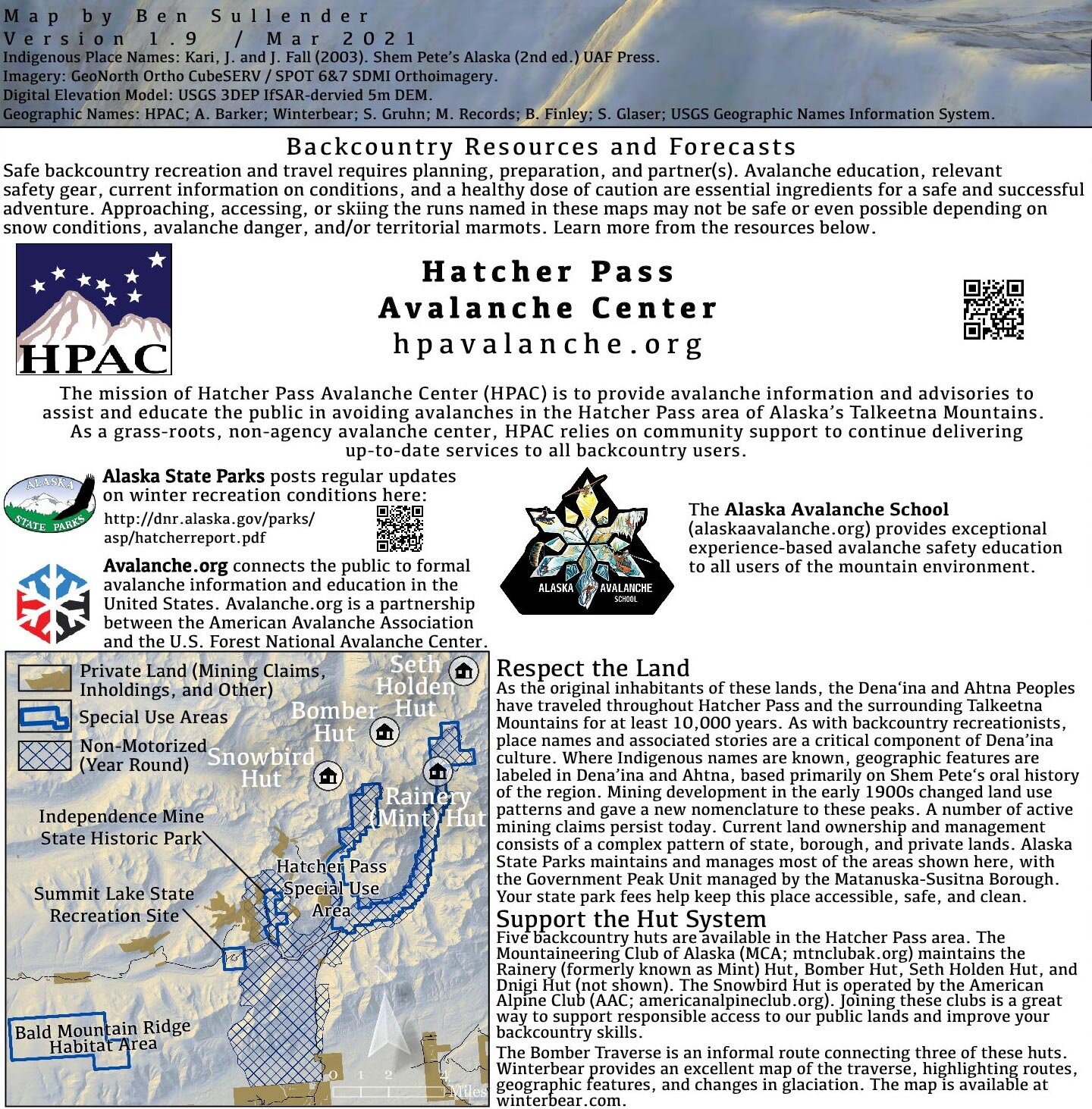
Produced in collaboration with the Hatcher Pass Avalanche Center (HPAC), this map highlights ski runs, peak names, Indigenous place names, and other key features of Hatcher Pass. This 24"x36" poster-style map is printed on glossy 100 lb. paper in full color. This map is an excellent addition to your living room wall, your “office” Zoom background, your gear room's map wall, and/or your sprinter van ceiling.
As a spatial analyst and a splitboarder, this map combines two of my core passions. After years of breaking trail, battling flatlight, digging countless pits, and kickstepping up couloirs, I’ve learned that nearly everywhere you go in Hatcher Pass, there’s a name and a story. By learning where we are in the mountains, we can situate our own experiences in a landscape of lore and backcountry legends. (Or at least we can situate our own pit results in a landscape of properly-named avy observations.) The Hatcher Pass Backcountry Geography map is the culmination of months of research, design, and review, stacked on a foundation of my own hard-earned firsthand beta.

Cartographically, I combined basic satellite imagery, a handful of vector features, and multiple digital elevation models at different resolutions to patch through cloud cover. I got fancy with a modified hillshade angled to reflect our far-north solar trajectory, a slightly fish-eye perspective to capture as many peaks as possible, and I pulled colors from my own Hatcher Pass photos to calibrate a custom color ramp capturing that unique golden hour light.
I pieced together Indigenous place names using Shem Pete’s oral history of the region and collected names for well-known ski runs from HPAC and experts from the skiing and climbing communities. The stories from both backcountry skiers and Alaska Native cultural use anchor the mountains with well-known peaks, rivers, ridges, lakes, valleys, and other features. By depicting some of these places cartographically, I hope that you’re able to find fresh facets across this incredible landscape.
Hatcher Pass is a lived-in landscape, from Ahtna and Dena’ina communities harvesting the abundant flora and fauna, early Western miners staking their claims, and skiers enjoying one of the longest ski seasons in North America. All three interwoven histories – Indigenous use, mining, and backcountry recreation – share a joy in combining knowledge and hard work to strike it rich, whether the riches you’re looking for are a group of caribou, a vein of gold, or untracked powder. Similarly, the foundation of that search is a shared understanding of the landscape. Although I wouldn’t say no to an in-season caribou, I mainly look for stable snow these days, and my search begins with HPAC’s forecast. HPAC relies entirely on community support to provide critical services that keep us safe and informed, and as we’ve seen with this year’s persistent slabs and the now-infamous drizzle crust, this is no small feat.
After covering the printing cost, all proceeds will be donated to the Hatcher Pass Avalanche Center - your map purchase directly benefits the expert forecasts that keep us safe and stoked!
As a grassroots fundraiser supporting a grassroots avalanche center, I’m running this effort through Google Docs, USPS, my personal online payment accounts, and without a credit card reader - thanks in advance for your patience with my grassroots commerce technology! You can also find (and purchase) these maps in AMH and at the Hoarding Marmot. Cheers to these awesome vendors for supporting the backcountry community.

Backcountry skiing is a dangerous activity and the features shown in this map are prone to frequent avalanches. Get the training, knowledge, equipment, and skills before you put yourself in harm’s way. The Alaska Avalanche School and Alaska Guide Collective offer critical courses to learn safe backcountry travel strategies, avalanche awareness, terrain management, and partner rescue. I consider these courses mandatory for anyone adventuring out into the mountains in winter. Resources like Avalanche.org, CNFAIC, and, of course, HPAC are great places to start familiarizing yourself with avalanche risks and safe backcountry travel strategies.


Approaching the Lost Couloir


The map, me, and some glorious sunshine on 4068’.